DRAINAGE MASTER PLANNING FOR CITY OF DORAL
CLIENTS: CITY OF DORAL – PUBLIC WORKS DEPARTMENT
LOCATION: CITY OF DORAL, FLORIDA
ESTIMATED CONSTRUCTION COST: $8,000,000
PROJECT DESCRIPTION / SCOPE OF WORK:
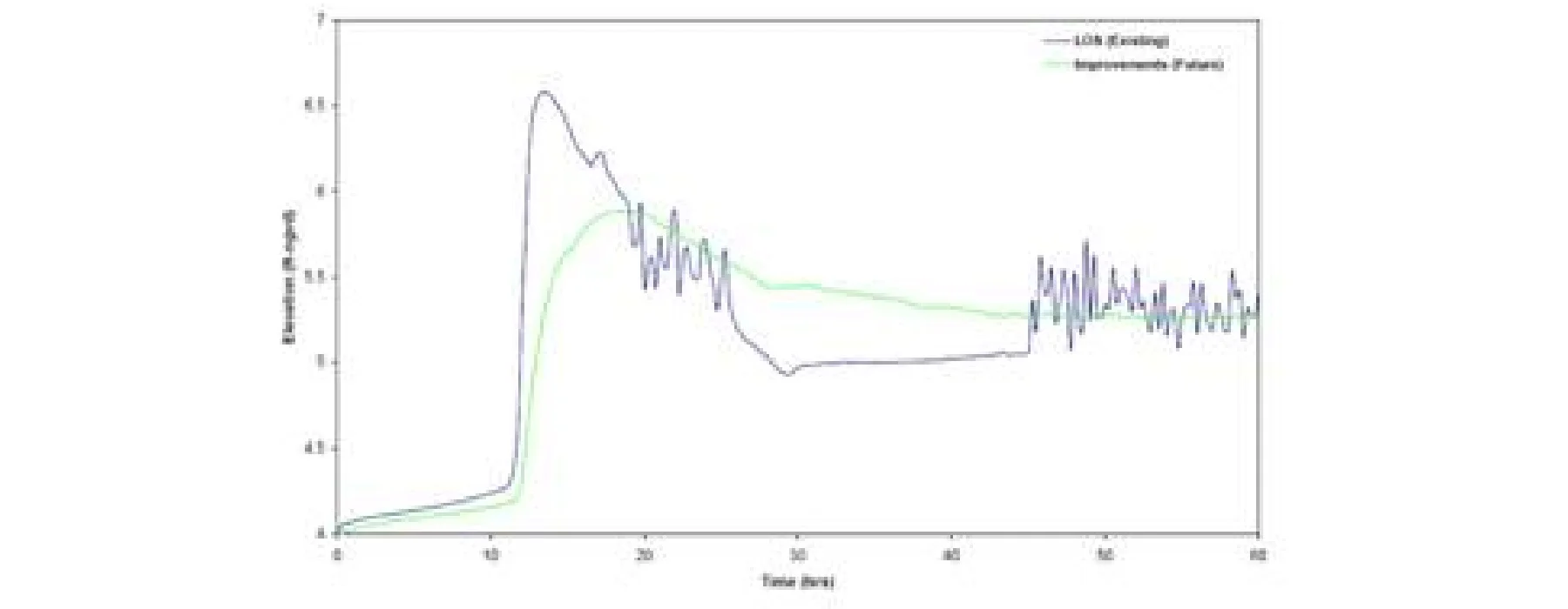
Contracted for stormwater master planning which was to perform data collection, existing conditions continuous simulation modeling, calibration of 5, 10,25 and 100 year storm events, Alternatives Modeling and Analysis, Alternative Designs, Conceptual design and permitting. Project was completed in February 2006. Project covered 25 square miles of coverage area with the Turnpike as the western boundary, SR836 (Dolphin Expressway) as the southern boundary, Okeechobee industrial area as the northern boundary and SR826 (Palmetto Expressway) as the eastern boundary condition.
The objectives of this project were to develop a SWMP to accomplish the following goals:
1. Analyze the Citys SWMP system and identify deficiencies
2. Propose improvements and develop a Capital Improvement Plan
3. Develop a plan to address Community Rating System (CRS) items
Stormwater master planning Doral Florida | hydraulic computer model (XP-SWMM)
Our team developed a hydrologic and hydraulic computer model (SWMM) to simulate the existing system and develop improvements. We performed the following tasks to accomplish the stated goals above.
This phased approach was performed on the following itemized tasks:
Phase 1: Collected and Developed Existing Information
- Coordinated with DERM to collect the existing models and information from reports currently being developed by other consultants including Earth Tech for the C-6 Basin and PBSJ for the C-4 Basin.
- Collected available information on the existing stormwater system from the City, DERM, and FDOT.
- Collected Hydrologic data using the SFWMD DBHYDRO Database and the USGS GIS Database.
- Developed a 3-D terrain model from LIDAR data and Hydrologic Information from that model.
Phase 2: System Evaluation and Capital Improvement Plan
- Constructed a Hydrologic and Hydraulic Model (Numerical Model) using SWMM.
- Simulated the Existing Conditions utilizing boundary conditions from the C-4 and C-6 canals (DERM models).
- Identified Deficiencies with Existing Conditions.
- Proposed Improvements in the problem areas that were discovered with Existing Conditions modeling and field verification with City Public Works staff.
- Modeled Alternative design improvements including control structure discharges to canals, culvert upgrades, proposed collection systems and exfiltration trenches.
- Developed a Capital Improvement Plan